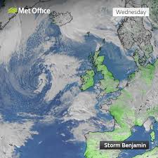
Britain is bracing itself for a major blustery assault as Storm Benjamin barrels in, aiming squarely at the south of England and the waters of the English Channel.
The storm — named by the French meteorological service but not yet officially by the Met Office — is expected to bring heavy rain, intense gusts and significant disruption across large swathes of the UK.
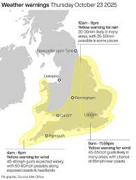
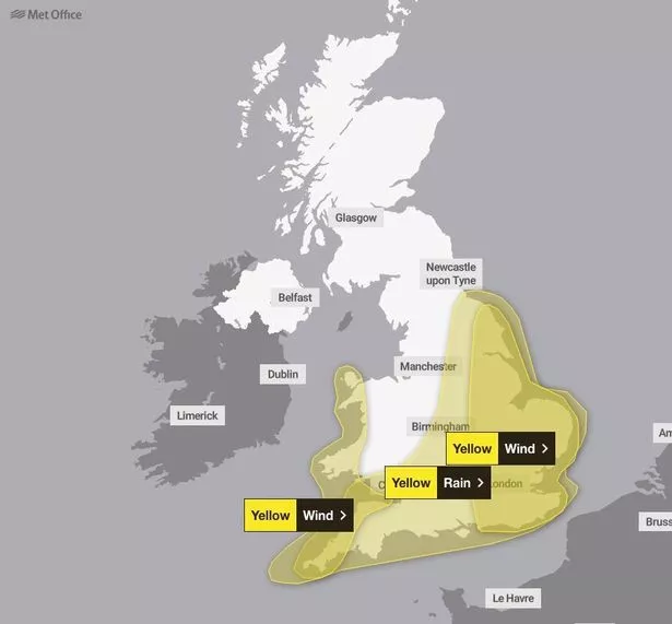
Storm Benjamin arrives as a deep low‑pressure system sweeping in from the west and pushing across southern England. The Met Office has issued several yellow “severe weather” warnings covering rain and wind.
- A rain warning covers much of southern England, the East Midlands, parts of Wales and Yorkshire from Wednesday evening into Thursday — with up to ~50 mm of rain possible by early Thursday morning.
- Wind warnings: End‑to‑end from the south coast across eastern England. Gusts of 50‑60 mph are likely quite widely, with 65‑70 mph near the coast and a small chance of exceeding 70 mph locally.
- In the south‑west and across the Channel coasts (Devon, Cornwall, Somerset, western Wales) gusts of 45‑60 mph are expected, especially on exposed headlands.
One particular region to watch: the English Channel and south‑coastal strip. As the storm scythes in from the Channel, those coastal zones and adjacent sea routes may see the worst of wind, wave motion and spray.
Focus on the South and English Channel
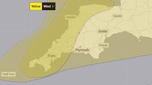
While the storm will affect large parts of England and Wales, the southern coast and the English Channel corridor are set to bear the brunt:
- The arrival route of Storm Benjamin runs across the English Channel into the south of England and on toward the North Sea. This means the south‑coast, maritime routes and Channel Islands may face the most aggressive wave and wind combination.
- Coastal roads, promenades and harbours along the south coast should prepare for large waves, sea‑spray and likely wind‑thrown debris or washed‑up material: the Met Office warns of “danger to life” from waves and beach material being thrown on to seafronts and coastal roads.
- For shipping and ferry routes in the Channel, the heightened winds and gusts (65‑70 mph+) mean extra precautions are needed: disruption to crossings is quite possible.
- Inland but near the south coast: gusts may be slightly lower but the combination of heavy rain and wind may lead to flooding, especially where drainage is poor or where rainfall hits saturated ground.
Potential impacts & what to expect
Residents, businesses and travellers in the path of Storm Benjamin should anticipate a number of potential disruptions:
- Transport: Ferry services, coastal train lines, seafront roads and bridges may suffer due to high winds, spray, wave overtopping and debris. Inland rail and roads may also face flooding, fallen trees or loose masonry.
- Power & infrastructure: With gusts reaching 70 mph in places, power cuts are a credible risk, along with damage to roofs, tiles, chimneys, garden furniture and temporary structures. The forecaster has explicitly noted the “small chance of injuries and danger to life” from flying debris or beach material.
- Flooding & water: Heavy rain of up to ~50 mm overnight in the south coupled with strong winds may lead to surface‑water flooding, especially in coastal zones, low‑lying areas and places with poor drainage.
- Coastal hazards: The channel corridor is at elevated risk for wave overtopping, erosion and possibly structural damage to sea‑walls or promenades. Residents and visitors should steer clear of cliff‑tops, sea fronts and coastal walkways during peak gust periods.
- Maritime: Vessels in the English Channel and near south‑coast ports should prepare for high seas and strong gusts; operations may be delayed or disrupted.
What you can do to prepare
If you live or are planning to travel in the south of England or near the English Channel, here are steps to take:
- Secure loose items outdoors (garden furniture, trampolines, bins, sheds) ahead of the storm.
- Avoid coastal walks, cliff‑tops and seafronts during the height of the storm. Large waves and debris may present a danger.
- If driving, allow extra time and reduce speed — especially on exposed roads, bridges and near the coast with spray or debris on the road.
- Check ferry/tunnel/port schedules if travelling via the Channel; be aware that services may be delayed or cancelled due to high winds or sea conditions.
- Keep abreast of local weather updates from the Met Office or other trusted sources — the storm track and intensity carry “greater than usual uncertainty”, according to meteorologists.
- Ensure you have a backup plan in case of power cuts or flooding: think phone chargers, torches, keeping mobile devices topped up, and clearing important drains or guttering if you are vulnerable.
Looking ahead
Though Thursday is set to be the most active day, the effects of Storm Benjamin may linger into Friday — especially for coastal zones where wind‑tossed surf and residual surge may continue.
Over the weekend, a cooler airmass is expected to follow, bringing blustery showers and perhaps temporary respite.
In short: Storm Benjamin may not be the headline‑busting hurricane‑level storm sometimes encountered elsewhere, but in the UK context it is significant.
Especially for the south coast and Channel corridor, it presents a real risk of “superior chaos” — heavy rain, high winds, large waves, transport disruption and potential damage. Better to prepare, batten down, keep aware and stay safe.